I took the City’s graffiti locations data set for a walk last Sunday in Brooklyn using the graffiti web app.
As discussed in my last post, mapping and animating the graffiti locations reveals patterns of paths and intensities. These are the locations of the graffiti that the City found and removed. The paths and intensities reveal a sequence – a potential order by which the two activities of graffiti identification and removal progressed. We can go back and trace that sequence, performing a comparative reading of the database record with the street.
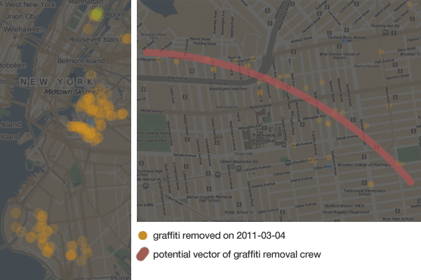
Brooklyn Graffiti Removal Tour - The Writing Path
Planning: I queried the database for those days in which the highest number of graffiti removals were recorded. The most active day for graffiti removal according to the data set for Brooklyn was March 4th, 2011. As we can see from the zoomed-out map above, there appears to have been a few crews at work that day. I zoomed in on the map and selected a portion of the locations that would be the easiest to walk. While there were quite a few good routes to choose from, I settled on one that would keep me nearest to Fort Greene (for a reason).
With my plan in hand, I set out on my journey to trace and annotate spatial data back to the street.
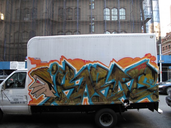
First thing I noticed was how mobile graffiti can be. This truck was parked across the street from a bank in the Upper East Side. The side of this truck is not a location one will find in the City’s list of graffiti locations. Shortly after, I came across a creek of bleach white water flowing out of a building and over the road. Seeking out a path of least resistance, it formed a figure upon the street.
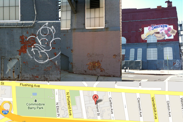
Along Flushing Avenue: My first stop was 2 Cumberland St. A Sweet ‘n Low factory. A large weathered sign proclaims it to the street. Below the security camera a recent tag. “March 4th 2011 – Cleaning crew dispatched. Property cleaned” states the record in the data set. Fresh paint is nowhere evident. Only a perfectly square paint job on the North side of the building suggests the location of a graffiti removal performed some time ago.
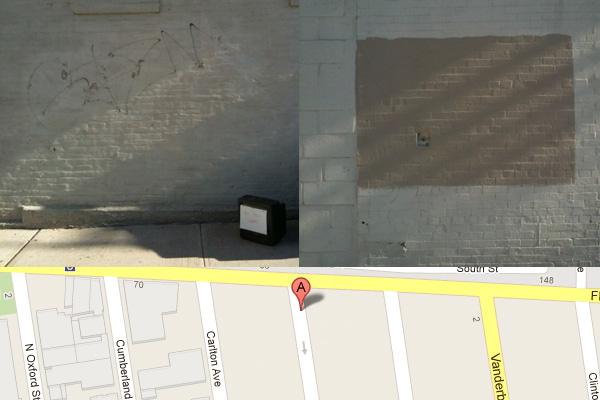
My next stop was Adelphi St. The data set reports graffiti removed here a couple of times within the past year. 7 Adelphi St had graffiti removed in March and in November. The same statement made on both occasions: “Cleaning crew dispatched. Property Cleaned.” Quite intriguingly, it appears that someone has physically tried to wash a tag off the wall. The paint buckled and peeled under the pressure. Evidently the plan didn’t quite work as intended and now it gives the curious impression that someone tried to excavate this tag buried under a layer of white paint.
The security gate of the light industrial building across the street is covered in graffiti. It probably was open when SCOUT came by.
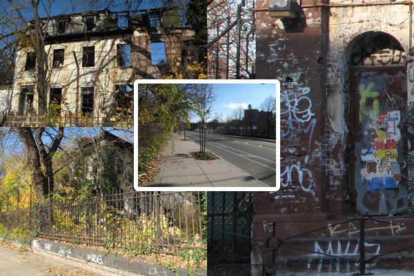
Moving down the street, I noticed how fresh Flushing St looks. Wide and smooth sidewalks, smooth paving, new trees. The South side of the street is made up of a combination of light industrial and mixed use buildings. The North side has a couple of large factories and quite few abandoned buildings. Trees and shrubs spill out from these burnt out buildings, covering up graffiti scrawled on the curb. Nature has a program of graffiti removal too.
176 Flushing Ave: A large warehouse. Layers of grey paint, in a variety of shades, mostly square. “March 4th – Cleaning crew dispatched. property cleaned.” 248 Flushing Ave: Starting to think the March 4th crew like performing neat square paint jobs. Just a brick-red square on the maroon wall. “March 4th – Cleaning crew dispatched. property cleaned.”
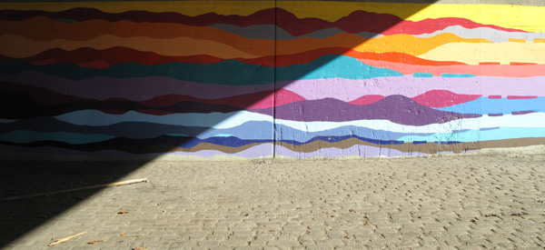
The trace takes me down to Park Ave. I cross under the Brooklyn-Queens Expressway. There is a large mural under the elevated freeway. It evokes a sense of the crossing: an ocean or perhaps two mountainous and colorful lands separated by water. The concrete divides the image. The light divides it further. A shopping cart and a few pieces of wood lie on the cobble stones.
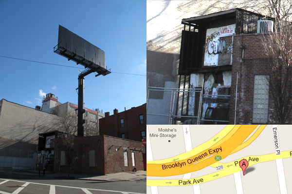
Toward Bedford: Towering over 342 Park Ave is a billboard with nothing on it. A large canvas communicating nothing to the drivers flying (or crawling) by on the BQE. 342 Park is the first brick building I’ve seen on my tour that has not been painted. The bricks are fully exposed. Along the North wall appears to be the trace of graffiti removed through some chemical process. It later occurs to me, after walking by, that the removed graffiti could be facing the immediate neighbor – a burnt out building that appears to have been severed in half. This building is not on the list of locations to be cleaned, yet the walls on either side of it have been treated.
Fran Tonkiss writes, “The moment at which graffiti stops being graffiti … is suggestive of how the city gets signified.” Tonkiss is referring to graffiti that becomes art and placed in galleries. Here, however, the graffiti seems to have been removed from the street – no longer identified as graffiti by city officials. What does it mean when graffiti is no longer read as graffiti on a dilapidated building?
148 Classon Ave: “March 4th – Cleaning crew dispatched. Property cleaned.” It is a light industrial building. There is graffiti on a door and a garage door. The scale of the graffiti on the garage door is larger than the ones on the door, but it compensates by the greater quantity of tags. Even a short metal fence seems to reduce the chance of a wall getting tagged. 81 Steuben: layers of paint creating the impression of a high-water mark sign or the mural under the BQE.
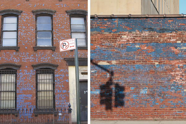
Walking down Steuben St, I fortuitously came across a building covered in blue-tape. An entire essay appears to have been written across 102 Steuben St. A sign over the door (also in blue-tape) spells out B.O.M.B. – Brooklyn’s Other Museum of Brooklyn. My immediate impression was of how similar the peeling blue letters looked to the peeling blue paint of a rather long stretch of wall back on Flushing Ave. This combination of blue and red brick seems to be a staple colour palette in the area – thinking back to the Sweet ‘n Low building too.
Yet, 102 Steuben St turns out to be tactical use of materials. The rather traceable author of this message, Scott Witter, covered his home with a political protest letter addressed to the mayor concerning the controversial Atlantic Yards project. Why blue-tape? The author told the Brooklyn Paper: “I [once] went out [with] a can of green paint and started painting. I got arrested right on Flushing Avenue. I spent 22 hours in jail. [And I learned that] tape is not considered graffiti because it’s temporary.”
Across the street from 102 Steuben is 89 Steuben St – a large warehouse. I exchange a greeting with a man unloading pineapples from a truck. Graffiti was removed from this building on March 4th. The record reads: “Cleaning crew dispatched. Property cleaned.”
Down Bedford:
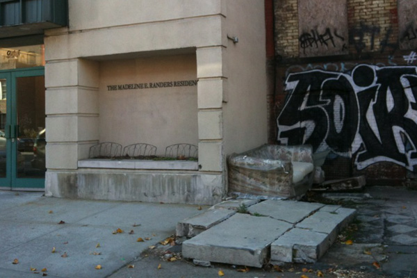
944 Bedford Ave: “March 4th – Cleaning crew dispatched. Property cleaned.” This is a photo taken outside between 944 Bedford (the building on the left) and its immediate neighbor (940 Bedford). Again, it appears that the property line becomes an important frontier of signification. Graffiti was identified on 944 and graffiti removed on the wall behind the couch. Yet, imagine moving the couch to paint the wall or walking past this and jotting down for removal the graffiti behind the concrete slab and couch.
9__ Bedford Ave: “March 4th – Cleaning crew dispatched. Property cleaned.” I’m obscuring the address, but the property of this inhabited single family home challenges the definition of “clean”. It is here that I realized that the phrase “property cleaned” actually serves to obscure the very thing that was removed. It isn’t about picking up the garbage, washing windows, mending a broken awning, or arranging the scattered objects left in front of the house. “Property cleaned” refers to graffiti, but refuses to identify it as such.
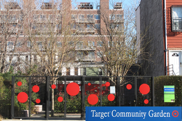
Across the street from the home on Bedford Ave is a pocket park with large red dots on the fence. These dots align with a red wall in the back of the park. Reading these dots together across an inaccessible park made me feel like I must be the subject of a corporate sponsored “community outreach project.”
“The more unlikely or risky the site,” writes Fran Tonkiss, “the greater the claims of the artist as a tactician of space.” Again, although Tonkiss is referring specifically to the graffiti maker as the artist, here the artist could be the actors involved in making this park and affixing those red dots. The “risky site” is a “rapidly revitalizing” neighborhood. By making a calculated contribution to this neighborhood, Target can promote its brand as an agent of change or social responsibility. Yet, to make this claim it has to suspend its sign across a highly controlled space.
I concluded my reading of the written space at 305 Franklin Ave. What a perfect place to take a break! 305 Franklin Ave is the address of an artisan doughnut bakery. While I didn’t exactly look too hard for traces of graffiti removal, I cannot help but wonder if the removal crew stopped in here for a tasty blood orange doughnut or perhaps the Passionfruit with Cocoa Nibs doughnut! Yes, polishing one of these off would certainly be worth a log entry. “March 4th – Cleaning crew dispatched. Property cleaned”.
“The practice of writing depends on a good reading of space: finding a site, making a reconnoiter of the scene, establishing points of access and getaway, choosing the moment.” Fran Tonkiss is referring here to the practice of writing graffiti on to the city, but perhaps this practice can also be seen in the work of the City’s graffiti removal. Why remove graffiti on one location, but not another? SCOUT is a synonym for reconnoiter – a strategic observation of the street. Are the paths through areas solely a traveling salesman problem? Is there a sense of the appropriate moment for reading and writing the city?
Certainly we may not be able to ascertain the city in the exact same sense as the consciousness that perceived it, but the act of walking the city by these records animates them with life and imagination. They become articulated and interpreted to the street and within the context of their authoring. It is a reading out loud.
Does it produce any meaning? I think so, but it is a cheeky meaning. Employing Roland Barthes’ definition of Eros in the reading of the city, Tonkiss says, “the city is intrinsically erotic as a space of exchange, of vitality and connection.” I would replace erotic with comic.
The city reads like a comedy where the cast of characters all seem to play their part with sincerity. A bureaucratic stamp pronounces victory upon properties adjacent to disaster. Graffiti returns as quick as it disappears. Paint on walls are not the only way to tag a building. This isn’t to say that it is a tragedy. Something does seem to be working here. With little more than exchanging a few words with people in the street, in walking the data set I experienced the street as a site of richly textual discourse. The vector of graffiti removal is one important arc in the spatial argument.
